I’m not sure where to start, as this is the first of many hiking articles and videos, not only of the Onondaga Branch of the Finger Lakes Trail but the whole Finger Lakes Trail System.
Should I introduce the North Country Trail first? A trail that extends across eight states totaling over 4,700 miles.
It’s where we started to hike, but even though many of these hiking excursions will be on the NCT, several hundred miles actually, I’m not hiking that trail.
The goal is to hike the Finger Lakes Trail system, a 950-mile hike with a 580-mile main trail and several branches extending north and south from the main west-to-east trail.

Finger Lakes Trail System in south-central New York State.
Clicking on the map will take you to the FLT website and interactive map.
It will be best to write an article on each of those two trail systems (I’ll link them) and concentrate on my hike.
The Onondaga Branch of the Finger Lakes Trail
I started hiking the FLT on the Onondaga Branch of the trail system. The main reason is that the part of the trail is closest to where I live.
The Onondaga Trail runs from the main trail southeast of Cuyler, New York, 40+ miles to the northern edge of the Tioughnioga Wildlife Management Area south of Cazenovia, New York.

The Onondaga Trail is highlighted in blue.
Besides the management area mentioned, the Onondaga Trail goes through Deruyter State Forest, Highland Forest County Park, Morgan Hill State Forest, Labrador Hollow Forest, and the Peage Hill State Forest.
I will include links to those areas when I write an article on the Onondaga Trail (I want to finish it all first).
Note that almost all of the write-ups on other websites describe the trail from south to north (main trail intersection to terminus). But I’m starting from the terminus and hiking south.
Also, I’m section hiking the trail and describing the sections with many photos along the way.
First Section Hike – NCT to Route 13
I found it odd that the start of the Onondaga Branch, a 40-plus mile section, does not terminate at a road or a parking area. Especially since the FLT follows the North Country Trail (NCT) a few hundred miles along the main and Onondaga trails. But stops a mile or so short of a good parking area.
Starting the Section Hike
I parked at the parking area at the elbow of Irish Hill Road. At this junction, the NCT follows the road north.
Caden and I were excited to get going, so we dove into the woods and headed southwest, following the NCT.

Caden is being patient. Here is where the NCT enters Irish Hill Road.
Hiking is all new to Caden. He is 6 1/2 months here and has never been in real woods or on a marked trail.
Everything was new to him.
Documenting the Section
The first couple of hikes are practice runs for both of us.
Eventually, we took more videos and will include trail videos in the articles.
In this one, and maybe the next couple, I want to show you the trail so you can decide if you want to take an afternoon and hike the section.
I did manage to take some videos of Caden; I was excited for him and his first hike. He loved and still loves streams. Below is a quick video of Caden’s first day on the trail!
My View From The Woods is a participant in the Amazon Services LLC Associates Program, an affiliate advertising program designed to provide a means for sites to earn advertising fees by advertising and linking to Amazon.com. As an Amazon Associate, we earn from qualifying purchases. We may earn a small commission from the companies mentioned in this post at no additional cost to you. Not all links are connected to affiliate companies.
Below are some photo galleries of the trail and the condition of the trail, photos of nature, and highlights along the trail.
Views along the Onondaga Branch Section
I’ll have a summary of the section at the end, including how many miles the section is and my thoughts.
But let’s start with some photos of the trail.
Below is a map of the first part of the section and photos of the bridge, or lack of a bridge, across the East Branch of Limestone Creek.

Click the photos below to expand them for better viewing and the description.
Note: My trail description, route, and conditions are explained as seen on the day of my hike. These can and will change with the weather, seasons, time, and maintenance. The explanation is meant to give the reader some idea of what may be encountered, not necessarily as they may find it later.
Bridge Out on the Onondaga Branch Trail
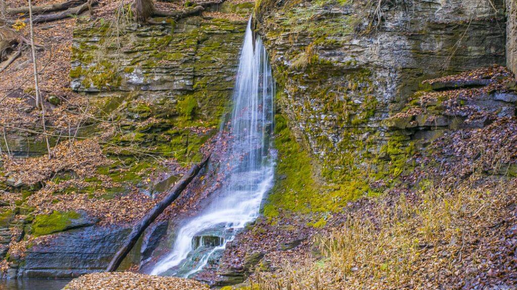
As we left the Tioughnioga Wildlife Management Area, we entered a beautiful hemlock forest and approached the east branch of Limestone Creek.
In the prior week, central New York had heavy rains that lifted the two-section bridge that crossed the creek and swept them to the creek banks. The bridge sections were held tight by ropes.

I pulled the left bridge back into the creek to jump across without going over the top of my hiking shoes.
Caden waded across. Then went back and crossed again. Repeat and repeat. He loves water!

Road Portion of the Section
After crossing the creek, you walk out into the pasture. Follow the hedge row to Damon Road (a fairly busy road). Walk up the hill about 9/10’s of a mile, then turn left onto Smith Road (no traffic). Walk up the hill about 7/10’s of a mile, and there is a car parking area for hikers.
Caden and I had lunch here.
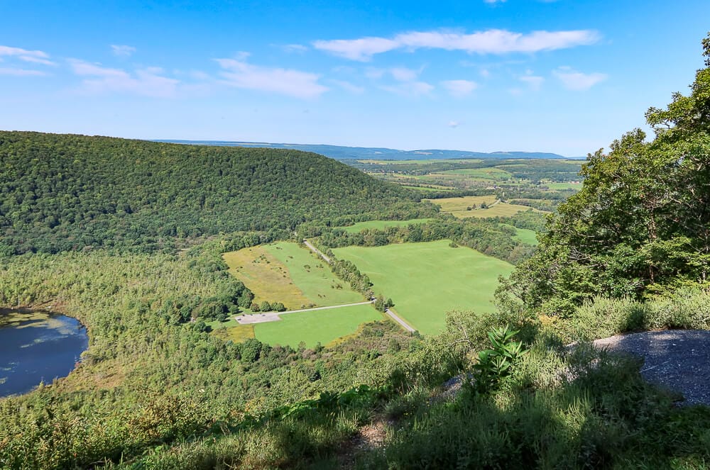
There are nice views overlooking the valley from the fields and roads.
From here, the trail goes down a driveway, then turns right into a field and eventually into the forest again before emptying into a couple of tractor paths and fields that lead you to Route 13.
Below is a map of the second part of the section and some photos of the overlooks. Click to expand the images for better viewing.

From Irish Hill Road to Damon Road.


Irish Hill Road to Route 13 Section Summary
The northern section of the Onondaga Branch of the Finger Lakes Trail
Overall this section was nice to hike. There was plenty to look at, and the terrain and vegetation frequently changed along the trail.
Mostly, the trail was dry even though it was raining quite a few days before the hike.
The 1.5-mile road hike (3 miles total since we had to hike the trail back to the car) isn’t much fun, especially with a puppy.
The creek views were nice, and since I’m a geologist, that gives me an extra excuse to look for fossils on the bedrock exposures.
According to my GPS, we walked 10.3 miles with a total ascent of 1,713 feet.
That makes the section between the NCT at Irish Hill Road and the Onondaga Trail crossing at Route 13 a bit over 5 miles.
MVFTW Trail Section Rating
Overall, I would give this trail section a 3 to 3.5.
However, in the first part, I walked from Irish Hill Road to Damon Road; I would rate that portion a 4.
Trail Section Ratings
These are how I rate the trails I hike.
- With a Trail Rating of 5, I would walk the trail anytime and recommend it highly to anyone.
- With a Trail Rating of 4, I’d definitely hike it again if someone wanted to hike the trail.
- With a Trail Rating of 3, if someone wanted the company to complete the trail, I’d go with them.
- With a Trail Rating of 2, nope, not again. Have fun if you want to do it.
- With a Trail Rating of 1, I’d laugh and turn away if asked to hike it again.
I hope you got something from this article. In the future, there will be more videos for sure.
As new articles are published on the different trail systems, additional links will be added to help bring more clarity.
After all, this hike occurred on the Onondaga Branch of the Finger Lakes Trail system and the North Country Trail.
In essence, this afternoon hike was 5 miles of a 44-mile trail and 5 miles of a 990-mile trail system, and 5 miles of another 4,700-mile trail.
If you have any questions or would like to use any of the photos, don’t hesitate to contact me, and I’ll get back to you.
Pin This Image to Your Pinterest Board