What are the 46 highest Adirondack mountains?
The answer depends on the reason you are asking.
There are two lists, the original list of the 46 highest mountains and the actual list of the 46 highest Adirondack mountains in more recent surveys.
The original survey of the Adirondack peaks contained what they thought were 46 mountain peaks with elevations of over 4,000 feet. However, that list included some peaks that weren’t quite high and omitted a few that are over 4,000 feet.
Why Are There Two Lists of the Highest Adirondack Peaks?
Because the original forty-six mountain peaks are still the mountains, you need to climb to be included in the famous Adirondack 46ers club.
You rarely hear anyone attempting to climb the actual Adirondack peaks over 4,000 feet. Even the Northeast 115 list includes the original 46 Adirondack peaks, not the actual 4,000 footers.
Brief Adirondack Forty-Sixers Mountain History
The mysticism of the Adirondack mountains’ high peaks has drawn people’s interest and wonder since the first eyes captured their beauty, vastness, and seemingly impenetrable wildness.
The effort to survey and document the Adirondacks began about 150 years ago.
But the thought of hiking the tallest peaks didn’t start until George Marshall and his brothers climbed Whiteface Mountain (now a ski resort) in 1918 and decided to do all of the 4,000-footers.
It took the Marshall brothers 8-years to complete the 46 highest Adirondack mountains, over 4,000 feet known at that time.
The first hiking club that was focusing on climbing the Adirondack mountains was the 46ers of Troy between 1936 – 1937. When the popularity of hiking in the Adirondacks increased, the club expanded and became the Adirondack Mountain Club in 1948.
It is more commonly called the Adirondack 46ers. Grace Hudowalski, the first woman to climb all 46 mountains, became the first president of the ADK forty-sixers.
As of 2020, over 13,000 people have climbed the original 46 highest mountains in the Adirondacks and claimed the right to be called a forty-sixer. We have information below on how to apply to be an official 46er.
Where Are The 46 Highest Adirondack Mountains?
The Adirondack State Park covers 6.1 million acres in upstate New York. Most of the 46 highest mountains are located in the heart of the Adirondack high peaks region between Lake Placid and the Keene Valley.

The Adirondacks has an interesting story. The natural resources around the perimeter of what we now call the Adirondack Park have been utilized for a long time.
But much of the interior was considered remote, wild, buggy, swampy, and the terrain too difficult to transverse. So people explored and settled in the western United States before surveying began in the Adirondacks.
The Adirondack Park is huge. It is the largest park in the United States. It covers 2 million more acres than Denali National Park.
How Accessible Are The 46 Adirondack Mountains?
Reaching the mountain peaks requires a wide range of hikes.
These include short walks and day hikes near Lake Placid and the 1980 Winter Olympic venues, stylish boutiques, and good food. In contrast, reaching the top of some mountains will take miles of walking and maybe overnight trips, camping at primitive campsites, and eating freeze-dried food.
Twenty of the 46 highest Adirondack mountains do not have marked trails to the top. Instead, these are accessible by what is called “herd paths.” Although not marked, these herd paths are well-worn into the mountainsides.
But because they are not official trails and the lack of maintenance increases the possibility of blowdowns and eroded rough trails. In addition, the risk of becoming lost in early or late snowstorms is also a possibility due to the lack of trail markers.

What to Expect When Hiking the High Peaks
Steepness-ruggedness
Many mountains, passes, and trails in the Rockies, Sierra, and Cascades are over 10,000, and some reach above 14,000 feet.
Mount Marcy is the highest point in the Adirondacks, at only 5,300 feet in elevation.
However, I wouldn’t scoff at the Adirondack mountains because of their relatively low elevations.
The Adirondack trailheads start at a much lower elevation, and there are a lot of feet of elevation gain and loss in the trails that lead to the mountain proper.
However, it’s not the total elevation gain but the steepness and ruggedness of the Adirondack mountains that will earn your respect.
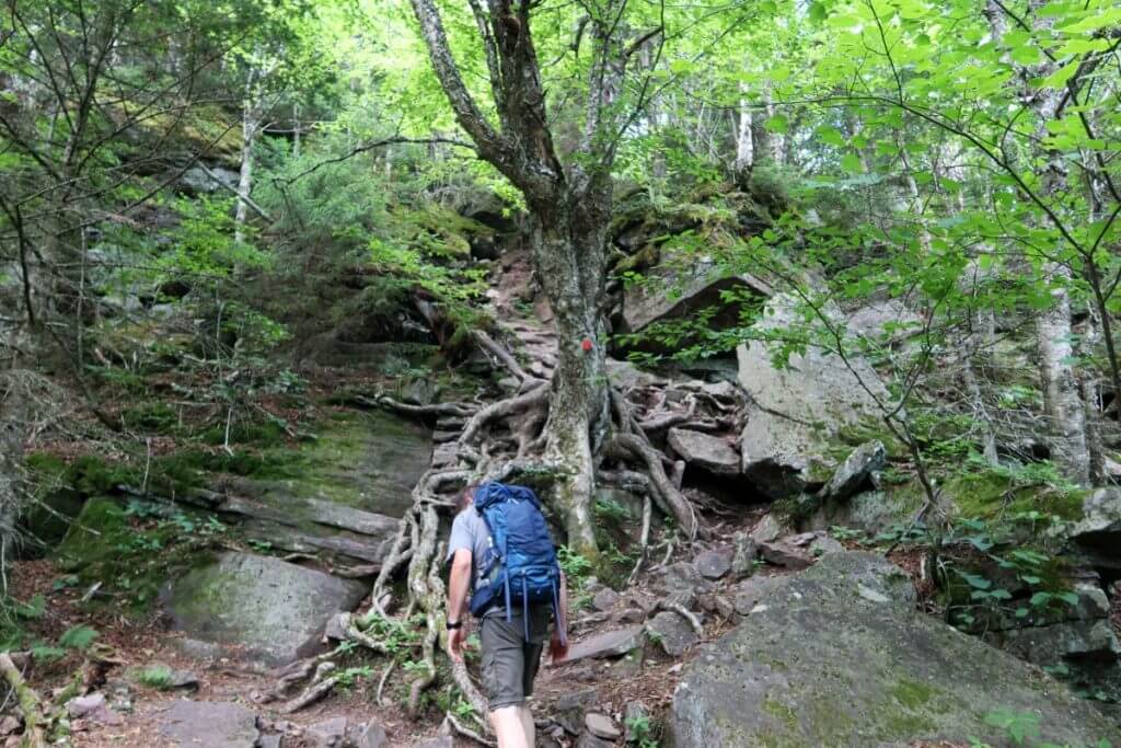
Switch-backs are non-existent. It is usually straight up the slope with rock scrambles, pulling yourself up boulders with nearby tree roots, or going up rock slides on all fours to avoid losing your balance and rolling down the rock face into the boulder field 100 or so feet below you.

Trail Conditions
For the most part, marked and even unmarked trails are easy to follow. Many Adirondack mountain trails start with a relatively level and benign lower part. These are well-worn but can be muddy during parts of the year or in the spring.

You can access many trails from places like Adirondack Loj (near Marcy dam) and the Adirondack Mountain Reserve (AMR), where you can access miles of trails.
They offer ample parking and easy trail access. However, AMR is private land and does have many rules and restrictions.
As you hike up in elevation, the trails become rocky, tree roots become more exposed, and you become faced with steeper climbs. In addition, it is easy to twist an ankle or slip on an angled tree root if one isn’t careful.

Trails on the upper sections of the Adirondack mountains are boulder-covered. Rocks and boulders create dams that hold mud, and when the boulders give way, the exposed anorthosite bedrock forms slides and rock slabs that are smooth and very slick when wet or icy.
Speaking of mud, many of the Cols between mountains contain bogs. For example, in the Santanoni Range, the trail to Couchsachraga Peak is infamous for its mud bog.
Watch the video below.
Trail conditions can change quickly. For example, the trail may resemble a stream or even waterfalls on the steeper sections after heavy rains or spring snowmelt.
Most high peaks’ upper sections require rock scrambling or rock climbing, where you have to use your hands to grab roots, cracks in the rocks, and even ropes and ladders to get up a steep section.
Coming down the mountain can be worst than going up. So don’t be too proud; sliding down on your butt is acceptable over falling or sliding down the smooth rock slabs.
Lack of Trail Markers

An unmarked herd path often has no trail markers and, as mentioned, can be less maintained than the marked trails.
Fellow hikers frequently create cairns to mark turn-offs or diverging routes.
The National Geographic Trails map set is a recommended guide for these adventures. Most maps of the Adirondacks mark herd paths with a dashed line on the map.
The herd paths are mostly easy to follow during the summer and fall seasons. However, following the trail when winter hiking or during the spring when snow remains on the trail’s upper reaches can be more difficult.
Sometimes There Is a Lack of Views
Many people get ticked off when they put in hours of effort to climb a mountain with no reward for a view.
Even though many of the 46er mountains have a treeless summit within the alpine zone, it doesn’t mean they will always have the best views. Cloud cover often obscures the view.

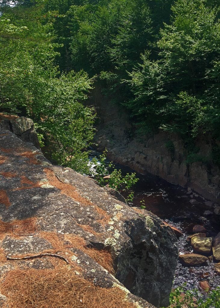
Some peaks are tree-covered and have no 360-degree views from the top. However, rocky ledges on the shoulders of the mountain often provide the best views and a great place to rest your legs.
When hiking the Adirondack Mountains, the trails are so steep that you get caught up looking in front of you, trying to find the best place to put your foot on or for something to grab.
Don’t forget to turn around once in a while. The trail provides an opening in the stunted weather-worn fir trees for views of the mountains across the valley from you.
You get a fantastic view when there is an opening and the weather is good!

Weather
Weather in the high peaks wilderness area can change rapidly—including extreme changes in temperature, precipitation, cloud cover, fog, and wind.
Even on good days, the temperature changes about 3.5 degrees every 1,000 feet in elevation change. Add to that temperature change, wind chill, lack of sun when in the clouds and fog, plus all the sweating from the hike up the mountain, and you can get chilled quickly.
Even in the summer, you can go from shorts and a tee shirt to a puffy jacket and wish you had some pants to cover your legs.
Here is a webpage that shows year-round climate data from a weather station at the Adirondack Regional Airport. The data is collected at the base level and not at the top of the mountains. So expect it to be cooler than the forecasted temperatures.
Be prepared for severe weather changes even during the warmest months.

Camping
There are many places to camp in the Adirondacks, ranging from RV parks to private and state campgrounds, including primitive campsites. These do fill up quickly during the summer.
Often campsites are booked well in advance, so planning is essential.
Primitive campsites are first-come, first-served.
Camping on state land is allowed but click here for regulations. Level spots for tents are hard to find, but hammocks work well. There can also be campfire restrictions.
Also, camping is not allowed above 4,000 feet in elevation.
Here’s the Answer to What Are The 46 Highest Adirondack Mountains
The first list is the original 46 highest Adirondack peaks, which you must climb to become an ADK 46er and earn your patch.
The ADK Forty-sixers take tradition over accuracy.
List of the Original Adirondack 46 Highest Mountains
| 1. | Mount Marcy | 5,344 |
| 2. | Algonquin Peak | 5,114 |
| 3. | Mount Haystack | 4,960 |
| 4. | Mount Skylight | 4,960 |
| 5. | Whiteface Mountain | 4,867 |
| 6. | Dix Mountain | 4,857 |
| 7. | Gray Peak | 4,840 |
| 8. | Iroquois Peak | 4,840 |
| 9. | Basin Mountain | 4,826 |
| 10. | Gothics Mountain | 4,736 |
| 11. | Mount Colden | 4,714 |
| 12. | Giant Mountain | 4,627 |
| 13. | Nippletop Mountain | 4,620 |
| 14. | Santanoni Peak | 4,607 |
| 15. | Mount Redfield | 4,606 |
| 16. | Wright Peak | 4,580 |
| 17. | Saddleback Mountain | 4,515 |
| 18. | Panther Peak | 4,442 |
| 19. | Table Top Mountain | 4,427 |
| 20. | Rocky Peak Ridge | 4,420 |
| 21. | Macomb Mountain | 4,405 |
| 22. | Armstrong Mountain | 4,400 |
| 23. | Hough Peak | 4,400 |
| 24. | Seward Mountain | 4,361 |
| 25. | Mount Marshall | 4,360 |
| 26. | Allen Mountain | 4,340 |
| 27. | Big Slide Mountain | 4,240 |
| 28. | Esther Mountain | 4,240 |
| 29. | Upper Wolf Jaw Mountain | 4,185 |
| 30. | Lower Wolf Jaw Mountain | 4,175 |
| 31. | Street Mountain | 4,166 |
| 32. | Phelps Mountain | 4,161 |
| 33. | Mount Donaldson | 4,140 |
| 34. | Seymour Mountain | 4,120 |
| 35. | Sawteeth | 4,100 |
| 36. | Cascade Mountain | 4,098 |
| 37. | South Dix Mountain | 4,060 |
| 38. | Porter Mountain | 4,059 |
| 39. | Mount Colvin | 4,057 |
| 40. | Mount Emmons | 4,040 |
| 41. | Dial Mountain | 4,020 |
| 42. | Grace Peak | 4,012 |
| 43. | Blake Mountain | 3,960 |
| 44. | Cliff Mountain | 3,960 |
| 45. | Nye Mountain | 3,895 |
| 46. | Couchsachraga Peak | 3,820 |
Click this link to see how to qualify to become an ADK Forty-sixer and earn your coveted 46er patch.
Revised Highest Adirondack Mountain List
Here is a revised list of the high peaks of the Adirondacks corrected by recent surveys.
You will see changes in elevation and mountains of the historic list switching places. There are only 42 Adirondack mountains above the 4,000-foot mark.
Modern surveying confirms Mount Marcy is still the highest mountain in New York State; poor Couchsachraga Peak fell from 46 in the original to a lowly 61st place ranking.
But hey, it still has its mud bog.
Presented below are the revised elevations and rankings.
Revised List of the Adirondack Highest Mountains
| 1. | Mount Marcy | 5,344 |
| 2. | Algonquin Peak | 5,114 |
| 3. | Mount Haystack | 4,961 |
| 4. | Mount Skylight | 4,925 |
| 5. | Whiteface Mountain | 4,865 |
| 6. | Iroquois Peak | 4,843 |
| 7. | Basin Mountain | 4,826 |
| 7. | Gray Peak | 4,826 |
| 9. | Dix Mountain | 4,823 |
| 10. | Gothics Mountain | 4,734 |
| 11. | Mount Colden | 4,715 |
| 12. | Giant Mountain | 4,626 |
| 13. | Santanoni Peak | 4,606 |
| 13. | Mount Redfield | 4,606 |
| 15. | Nippletop Mountain | 4,593 |
| 16. | Wright Peak | 4,587 |
| 17. | Saddleback Mountain | 4,442 |
| 18. | Panther Peak | 4,515 |
| 19. | Armstrong Mountain | 4,429 |
| 20. | Table Top Mountain | 4,413 |
| 21. | Hough Peak | 4,409 |
| 22. | Rocky Peak Ridge | 4,390 |
| 23. | Macomb Mountain | 4,370 |
| 24. | Mount Marshall | 4,364 |
| 25. | Allen Mountain | 4,347 |
| 26. | Seward Mountain | 4,331 |
| 27. | Esther Mountain | 4,230 |
| 28. | Upper Wolf Jaw Mountain | 4,203 |
| 29. | Big Slide Mountain | 4,199 |
| 30. | Lower Wolf Jaw Mountain | 4,173 |
| 31. | Phelps Mountain | 4,160 |
| 32. | Street Mountain | 4,134 |
| 32. | Sawteeth | 4,134 |
| 34. | Mount Donaldson | 4,180 |
| 35. | Cascade Mountain | 4,098 |
| 36. | Seymour Mountain | 4,091 |
| 37. | South Dix Mountain | 4,068 |
| 37. | Porter Mountain | 4,068 |
| 39. | Mount Emmons | 4,039 |
| 40. | Mount Colvin | 4,035 |
| 41. | Grace Peak | 4,026 |
| 42. | Dial Mountain | 4,003 |
| 43. | MacNaughton Mountain | 3,983 |
| 44. | Blake Mountain | 3,970 |
| 45. | Green Mountain | 3,960 |
| 46. | Cliff Mountain | 3,944 |
| 47. | Snowy Mountain | 3,899 |
| 48. | Lost Pond Peak | 3,891 |
| 49. | Kilborn Mountain | 3,881 |
| 49. | Blue Ridge Mountain | 3,881 |
| 51. | North River Mountain Peak | 3,878 |
| 52. | Panther Mountain | 3,862 |
| 53. | Sentinel Mountain | 3,858 |
| 54. | Sawtooth Mountain | 3,839 |
| 54. | Nye Mountain | 3,839 |
| 56. | McKenzie Mountian | 3,832 |
| 56. | Avalanche Mountain | 3,832 |
| 58. | Teddy Roosevelt Mountain (T.R. Mountain) | 3,822 |
| 59. | Lyon Mountain | 3,820 |
| 60. | Averill Peak | 3,803 |
| 61. | Couchsachraga Peak | 3,793 |