Follow along as we section hike the Onondaga Branch of the Finger Lakes Trail System. We break down the trail into short hikes with easy access and trailhead parking.
In this article, we hike the Onondaga Trail section from Fairbanks Road within the DeRuyter State Forest to a large parking area on East Lake Road along the eastern shore of DeRuyter Reservoir.
We include a map of our walk, photos, and videos of the hike.
An East-to-West Hike from Fairbanks Road to DeRuyter Reservoir Along the Onondaga Trail
The hike is short. My GPS marked it as 5.6 miles with an elevation change of 1,248 feet. Caden and I did it after hiking east from Fairbanks Road to Route 13 and back.
This section of the trail is on the Finger Lakes Trail Map O2. You can also use the Finger Lakes Trail website interactive map.
Note: If you are doing a day hike, don’t plan on hiking all of the Onondaga Trail. I suggest starting your walk at the East Lake Road parking area along DeRuyter Reservoir. I state my reasons for this at the end of the article.
Fairbanks Road Parking Area
Fairbanks Road is located south of New Woodstock, New York. Google Maps has no problem locating it, and the parking area is easy to find.

Parking Area on Fairbanks Road.
Note: My trail description, route, and conditions are explained as seen on the day of my hike. These can and will change with the weather, seasons, time, and maintenance. The explanation is meant to give the reader some idea of what may be encountered, not necessarily as they may find it later.
Starting the Onondaga Trail Section from Fairbanks Road
The photo above looks to the northeast and toward the start of the previous section. For this section, start hiking south down the hill on Fairbanks Rd. After a short while, you will turn west before you come to an open field.
As you can see in the map photo below, there is some disconnect between the mapped and marked trails. Please follow the marked trail. However, this is the worst part: it goes through a low, wet, boggy section before heading into the woods.

Fairbanks Road Parking to Stanton Rd Crossing. The red line is my GPS track.
Enter DeRuyter State Forest
The trail between Fairbanks Rd to half a mile past Stanton Rd cuts through DeRuyter State Forest. The forest is one of many state forest lands that no one except the locals knows about.
DeRuyter State Forest is shaped much like the state of Utah and covers 927 acres. Primate camping is allowed in the forest if NYSDEC’s rules and regulations are followed.
The first few hundred feet of the trail are a bit wet and muddy.

But soon, you enter the forest, and the trail is dry and well-marked. Click any image in this article to expand it for better viewing.
Follow the blue blazes for the Onondaga Trail.
Remember, the Onondaga Trail is a part of the Finger Lakes Trail and the North Country Trail.


Not far into the trail, you come across a small stream. Continuing westward, you cross Tromp Road.
There is a campsite south on Tromp Road next to a small pond. However, we did not take that path but instead continued west.
")
Caden loves streams!

Cross Tromp Road. There is parking here, and two-tenths of a mile to the south, there is a campground and a small pond. We did not hike to the campground.
Four-tenths of a mile past Tromp Road, you cross Stanton Road. There is no parking here.

Stanton Road at the Onondaga Trail Crossing.
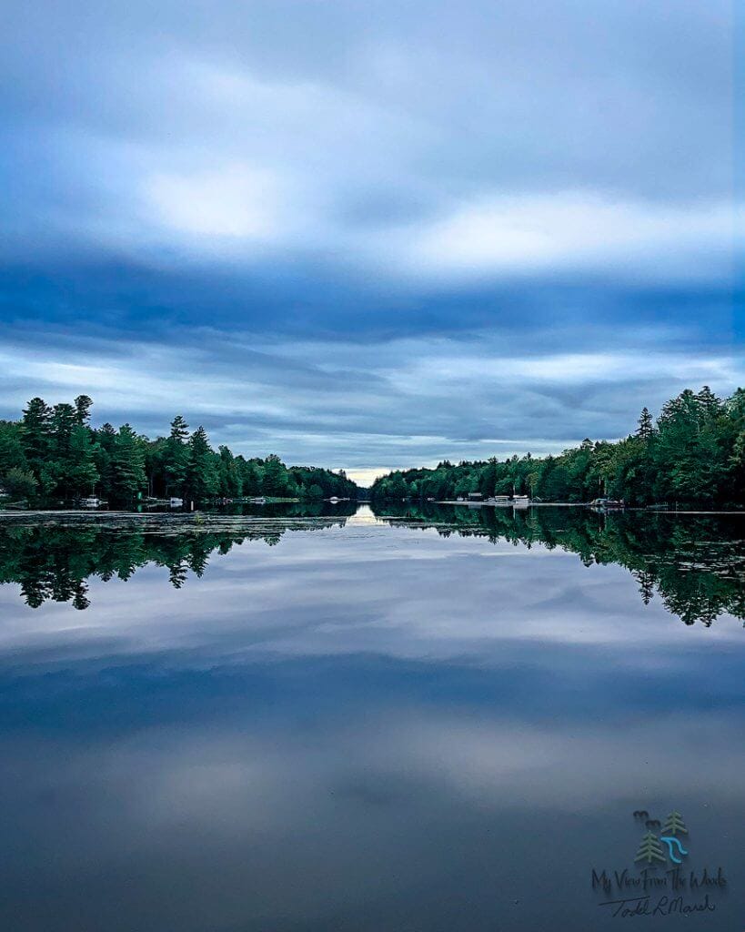
The trail is very open, wooded, and beautiful. There is even a good view of DeRuyter Reservoir from the Onondaga Trail. Again, you can click any image in the gallery below to expand it for better viewing.
The Second Part of the Trail Section
The view of DeRuyter Reservoir is after you leave the State Forest peak a hill and start walking down toward East Lake Road and the Lake.
Below is a map and our travel along the trail.

Stanton Road crossing to East Lake Road Parking Area near DeRuyter Reservoir. The dark red line is my GPS track.
Not only does Caden love to play in the flowing streams, but I like to look for fossils in the Devonian-aged rocks.
The forest in this section of the trail is open and fantastic to walk through. However, the trail is steep in places, as you can see in some of the images below.
But the switchbacks make the hike much better in the steep areas.


After playing in the stream, we followed it along the trail to East Lake Road.
There’s a large grassy parking area that hikers can use to park their cars here.

The trail enters the parking area to the left of the dead tree in the background. Caden is looking at the East Lake Road entrance.
My View From The Woods is a participant in the Amazon Services LLC Associates Program, an affiliate advertising program designed to provide a means for sites to earn advertising fees by advertising and linking to Amazon.com. As an Amazon Associate, we earn from qualifying purchases. We may earn a small commission from the companies mentioned in this post at no additional cost. Not all links are connected to affiliate companies.
There Are Many Interesting Things to Look at Along this Section of the Onondaga Trail
Below are some of the interesting things I saw along the trail. Again, you can click an image to expand it.


Summary of the Fairbanks Road to East Lake Road Section Along the Onondaga Trail
This short section is only a little over 5 miles round trip. Caden and I did this section along with the section to the east on the same day.
The only wet spot was the first couple hundred feet once you left Fairbanks Road. So we cheated on the way back and walked through the field to the road.
It wasn’t much drier but less muddy.
For that reason, if I were to hike this section again as a day hike, I’d reverse my course. Start at the large East Lake Road parking area and walk the trail eastward. Then skip the wet portion and walk on Fairbanks Road.
Of course, if you are hiking all of the Onondaga Trail Branch, it doesn’t matter. It all has to be covered.
Besides that, the trail was in great shape! Well maintained by the Onondaga Chapter of the ADK members.
The hills had some steepness, but the route of the trail made it reasonably easy.
According to my GPS, the elevation gain over the trail length was about 1,250 ft.
Caden and I both had an enjoyable time.
MVFTW Trail Section Rating
I will rate this section of the Onondaga Trail as a 5.
The trail was excellent initially despite the short road section and wet weeds.
It would be a good morning or afternoon hike with easy parking, views, streams, little waterfalls, and a beautiful wooded trail.
Give it a try!
Trail Section Ratings Guide
These are how I rate the trails I hike.
- With a Trail Rating of 5, I would walk the trail anytime and recommend it highly to anyone.
- With a Trail Rating of 4, I’d definitely hike it again if someone wanted to hike the trail.
- With a Trail Rating of 3, if someone wanted the company to complete the trail, I’d go with them.
- With a Trail Rating of 2, nope, not again. Have fun if you want to do it.
- With a Trail Rating of 1, I’d laugh and turn away if asked to hike it again.
I hope you got something from this article. There will be more videos in upcoming articles.
As new articles are published on the different trail systems, additional links will be added to help clarify how all of these sections fit into each trail system.
After all, this hike occurred on three trails—the Onondaga Branch of the Finger Lakes Trail system as well as on the North Country Trail.
If you have any questions or would like to use any of the photos, please reach out to me, and I’ll get back to you.